Tagged: #Beta #Map and track issues
-
AuthorPosts
-
31 August 2023 at 6:50 pm #3009
 Ejj75Participant
One opinion/change proposal.
The maximum tilt angle of the map could be more, so you could see the route further ahead without having to change the zoom level.
31 August 2023 at 6:54 pm #3010 SeverianParticipant
You can charge the tilt level in map view. Just use two finger gesture.
31 August 2023 at 7:09 pm #3011Ejj75ParticipantYou can charge the tilt level in map view. Just use two finger gesture.
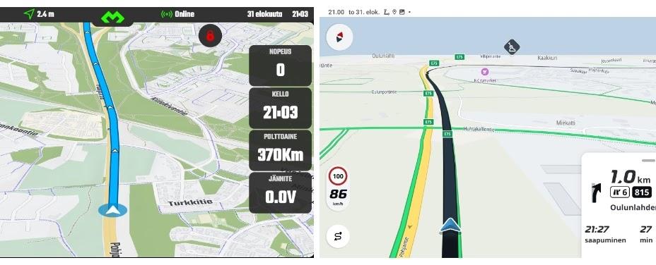
Yes I know. My proposal is tilt more. See example from screenshots below. You can see couple of next turn about same zoom level if tilt level is more.
 1 September 2023 at 4:59 pm #3015
 João PereiraKeymaster
So John I have to correct myself .The problem is the user Interface is now inconsisten.Its a short click on obd page and a long click on Map view you should align this
Yup you are right I need to change this. Thank you for reporting.
Beta 2.99950: – When map is locked (with the touch screen lock settings enabled) other UI elements are hidden too
The idea is good. But, right now you remove bottom UI elements (menu) and show the same map area in increased screen space, which results in different aspect ratio. This is unpleasant, since eye catches this change (to prove my point: locking button is also a little bit distorted after reshaping of the map, not perfect circle anymore). In my opinion, aspect ratio of the map and zoom level should stay the same after locking, so you just show increased “map area” (a little bit), that fit to screen. Best!!
This one GREATLY depends on the device you are using… and to be honest this is going to be a tough one to solve… I will make some testing and see what I can do.
Hello John There is a question about the automaticaly searched for pois alongside a track. Are these pois measured as a direkt line which meanns the gas station could be on the other side of the mountain or is there a defined distance between track and poi so they are shown in the box or not. Are they around my actual position or allways in direction of the track i am following?
Basically we sweep the track, point by point, and at every 5Km interval (along the track) we do a 10Km radius search for POI (being the track point the center).
So a POI can be up to 5Km away from the track in straight line.
We can add options to allow the user to fine tune these values.DMD2 Project Manager & Lead Developer
Buy Me a Coffee1 September 2023 at 5:00 pm #3016João PereiraKeymasterYou can charge the tilt level in map view. Just use two finger gesture.
Yes I know. My proposal is tilt more. See example from screenshots below. You can see couple of next turn about same zoom level if tilt level is more.
This wont be something I will be able to change anytime soon, this requires changes in the map engine that will take A LOT of time so I will have to leave this for later, sorry.
DMD2 Project Manager & Lead Developer
Buy Me a Coffee1 September 2023 at 6:14 pm #3017ParaenduristParticipantTo ad this option would be a great idea. But you should also take into acount how far it is on road or trail to arrive there. I had this problem on tet greece last year my garmin said 20 km but this was on the opposite side of the mountain an it was impossible to get there. I was left without gas and was lucky that somebody picked me up 50 km away from the next reachable gas station
8 September 2023 at 9:57 pm #3028BrutusParticipantDoes the updates in DMD2 BETA installs automatically, or do i have to do it manually, and if so, how?
12 September 2023 at 9:40 pm #3030DerekBParticipantDisregard. I was not in the Beta program.
—————————-
original post: I’m using Colorado/Wyoming maps and when tracking a ride I am getting a huge number for miles traveled. The miles and speed under the trip tab are correct. Settings issue?
 14 September 2023 at 12:34 pm #3033João PereiraKeymaster
Beta 2.99951:
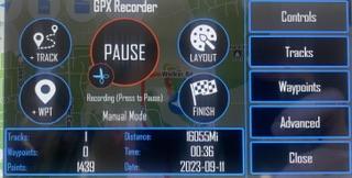
– Release: GPX Recording Initial Release -> Settings coming soon
– Map Screen Lock will show Follow Location Button and Recorder Button
– Fixed a case where map download progress would not show
– Greatly improved the map download code
– GPX Tracks – Added Orange and Purple colors
– Updated POI Category IDs to reflect latest map updates
– Fixed a case where the “Options” button in the route progress box would work when screen touch is lockedDMD2 Project Manager & Lead Developer
Buy Me a Coffee14 September 2023 at 4:48 pm #3035João PereiraKeymasterBeta 2.99953:
– Release (might take time till it reached Playstore):
– GPX Recording fixed a case where saving Files with illegal filename chars would not save the GPX
– GPX Recording fixed an issue where deleting all recordings would crash on delete last one
– GPX Recording fixed a crash when clicking “Tracks” when no point was recorded yet
– Overall App -> Share function for GPX would crash on DMD-T devices when using SD Card
– Fixed a case where after updating a map it would still show as update availableDMD2 Project Manager & Lead Developer
Buy Me a Coffee -
AuthorPosts
- You must be logged in to reply to this topic.