Tagged: #Beta #Map and track issues
-
AuthorPosts
-
27 March 2023 at 10:00 am #1458
 João PereiraKeymaster
Hi, downloading maps is now working, i have two maps (Luxembourg, and Germany) enabled but still nothing is visible. Map is completely white.
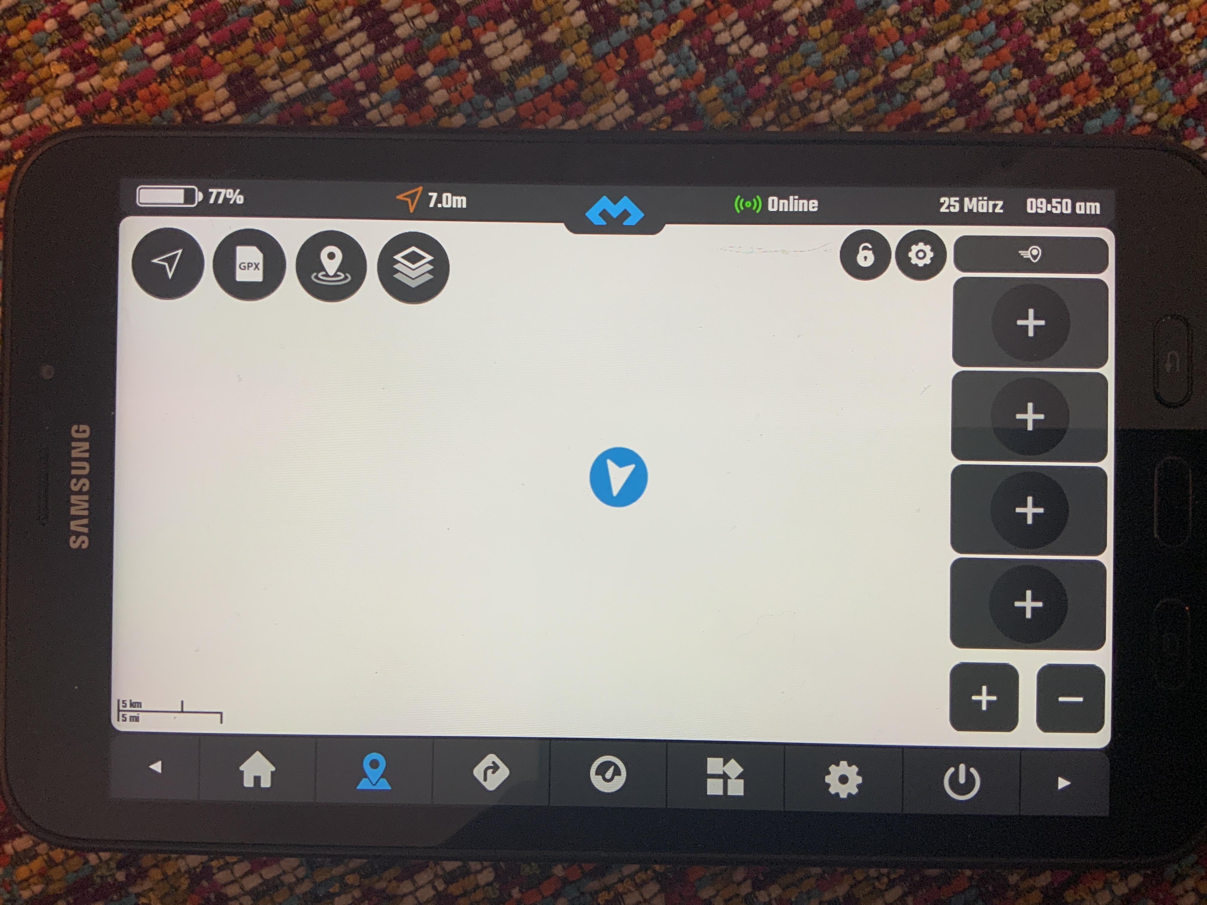
Can you please zoom out and check if at least the world map (white for land, blue for oceans) is loaded.
Also, what Android version is on that device?DMD2 Project Manager & Lead Developer
Buy Me a Coffee27 March 2023 at 2:25 pm #1459 jesperParticipant
Hi again
I don’t know if it’s a bug, but when I try to tap on the different “Buy Plugin” buttons, nothing happens. Both on APK install and Play Store version.
BR
Jesper
27 March 2023 at 3:17 pm #1460ParaenduristParticipantHello John .Congrats big improvements on 2.99 Poi search along Tracks is fantastic. External music Widgets Work.
I would Like to have an improvements.Would IT bei possible to automaticly load Maps when You are nearby a Border lets say 50 km away.
There IS a Bug in 2.99.System Crashes Sometimes when in was in Locus maps and Change to the Maps in dmd2 and dona search there. I am on Carpe Iter.This happened severalbtimes.I have to Stop dmd2 and reload
27 March 2023 at 7:47 pm #1461ParaenduristParticipantHello John I played arround with dmd2 and the GMX File for my next Trip ITS about 5600 km and 85 Poi. When i Play arround after some time dmd2 Stands still I even cannot exit.I have to kill dmd2.This Happens on my MIUI 11t pro as Well aß my Carpe iter. Version 2.99
28 March 2023 at 9:50 am #1462 BenParticipant
Can you please zoom out and check if at least the world map (white for land, blue for oceans) is loaded. Also, what Android version is on that device?
Hi again,
the device has Android 9 – at that time the world map was not loaded, even when i tried a few hours later.
I checked again this morning, so a couple of days later, and all maps were now visible – no problem with enabling or disabling the maps, everything fine so far.
No idea why that happend, but what i know is that i am very short with storage space on my tab active maybe this could be an issue? I would really like it if maps could be loaded onto an external memory.
Thankyou for your efforts and the good work, I am looking forward to the things that are still to come.
Ben
28 March 2023 at 10:49 am #1463Abyss79ParticipantHello John I`m doing some test, and with new version all is fine… also ODB now is working.
It will be nice to have the next poi and next Waypoint accessible also in the Home Page.
Like having the Map widget on the right and the next destination on the left.
In this way you can have maps and Speed and all the other data under controll in a singol page.What about turn by turn navigation on the GPX when we can test it?
Good job so far… keep going!!
Christian28 March 2023 at 1:31 pm #1464jesperParticipantHi John
Talking about turn-by-turn…. how is that implemented? Do you need to have premade GPX? Does DMD2 have a built in routing engine or is it dependent on a online routing engine?
OsmAnd is a very good and powerful offline navigation app, with offline routing engine. But I guess you are familiar with it.
Will DMD2 be able to use the same map files as OsmAnd if you set OsmAnd to use the shared storage on the device? I am asking since both DMD2 and OsmAnd are using Open Street Maps. This way you would avoid having duplicates of the maps.
OsmAnd has an API for integration with other apps. This could maybe simplify map downloads, route calculation, GPX generation and other tasks? The only downside I see is that OsmAnd has to be installed alongside DMD2.
OsmAnd has a demo app for the API where you can test some of it.
Just to be clear: this is a local API in the OsmAnd app, not an online API on the internet.
BR
Jesper
28 March 2023 at 2:13 pm #1465João PereiraKeymasterHi John Talking about turn-by-turn…. how is that implemented? Do you need to have premade GPX? Does DMD2 have a built in routing engine or is it dependent on a online routing engine? OsmAnd is a very good and powerful offline navigation app, with offline routing engine. But I guess you are familiar with it. Will DMD2 be able to use the same map files as OsmAnd if you set OsmAnd to use the shared storage on the device? I am asking since both DMD2 and OsmAnd are using Open Street Maps. This way you would avoid having duplicates of the maps. OsmAnd has an API for integration with other apps. This could maybe simplify map downloads, route calculation, GPX generation and other tasks? The only downside I see is that OsmAnd has to be installed alongside DMD2. OsmAnd has a demo app for the API where you can test some of it. Just to be clear: this is a local API in the OsmAnd app, not an online API on the internet.
BR Jesper
Our route calculator is fully offline. We are building it on both DMD2 app and there will be a planner for the webrowser that will sync with the app.
We will release it in stages and improve it as we go, so initially you will probably only have the app version, and on the app there is work being done for the different things that make up the full system:
– Download calculation map files along with the map downloads
– The UI for the user
– The different calculation profiles, just as example: road fast, road avoid tolls, off-road easy, off-road medium, off-road hard, stuff like that…
– The indications while riding, like distance to next turn, turn type, etcI plan to release the first, very simple version, in one or two weeks.
I also try NOT to use any other app or become dependant of any other app, I really do not like to be influenced by the way other apps are working, mostly because the initial reason that made me develop this was the fact that there was not a single app that felt that was made to be used while you are on the motorcycle. So im using this very simple philosophy:
– Anything a user might want to do while riding, even if he needs to stop, should be available with a maximum of two taps (two clicks)
example, search for gasoline: Tap1: POI icon, Tap2: Gasoline button, DONE
example, hide or show GPX: Tap1: GPX Icon, Tap2: hide or show icon for the GPX
The third level interaction is to be avoided unless its REALLY required and is in the flow of the first tap, for example, accessing the waypoint list: Tap1: GPX Icon, Tap2: Tap on GPX file to view, Tap3: Tap on Waypoints button
Going trough menus, and various levels of menus while riding is a NO GO for me… so to avoid complex structures and too much user interaction I need to re-think many “standard” ways that all the other apps use and at the end of the day I think thats people try DMD2 and stick to it, most of them cant really explain why they like DMD2, but I think its the simplicity of the features that you would normally use while riding.Also… I ride… and sometimes I ride for days… if anything feels too much trouble while riding I will “feel” it, I will come back from my ride and just change it.
Hello John I`m doing some test, and with new version all is fine… also ODB now is working. It will be nice to have the next poi and next Waypoint accessible also in the Home Page. Like having the Map widget on the right and the next destination on the left. In this way you can have maps and Speed and all the other data under controll in a singol page. What about turn by turn navigation on the GPX when we can test it? Good job so far… keep going!! Christian
Track Progress widget is coming!!! FOR SURE, as it is already in my todo list for the next run.
Im now working in releasing the first VERY basic route planner.Again… DO NOT expect yet another planner. Specially as the planner evolves you will see very specific offroad and adventure features. Just out of my head, I can think about the most desirable features for own usage:
– One Dialog to Plan (even if it might be a chained steps dialog), bammm done, another tap to share that planned route with your friends in GPX Format… done, quick and simple.
– On planning I want an option to AVOID certain loaded GPX, there is nothing I hate more than returning back home using the same track I used to get somewhere. So if I just arrived to the end of the GPX or calculated route, I want to be able to calculate a route back without having to go through the same paths I just did.
– LOOP IT, a quick option on route calculation where I press the destination, it calculates my route to the destination AND then I just press “LOOP BACK” and it adds another calculation from the destination to where I am, using same logic as previous stated, avoiding going through same paths (this would cover my typical Saturday rides, I want to arrive somewhere, off-road, and then come back)This kind of things are mandatory for me, why? Because I ride! Obviously there are super complex things the calculator can do, like use ground type, slop degrees, bla bla bla, but at the end of the day it needs to have quick and simple user interaction and offer (without 1000 menus) really useful options for us, motorcycle riders, who go off-road and adventure!
Beta 2.991 and previous 2.99:
– Fixed and improved POI search for big files
– New Map language option in map settings page
– Added map lock (map full screen + additional option in map settings to disable touch)
– Track progress box now gets hidden correctly when no info to display
– GPX Manager dialog no longer gets transparent on file click and track click
– GPX Files loaded by order as they where original loaded
– Waypoint title stroke now always white, even on light theme
– Fixed a crash on POI search when no location fix was available
– Added conversion from GPX Routes to GPX Tracks
– Other small improvementsDMD2 Project Manager & Lead Developer
Buy Me a Coffee28 March 2023 at 3:44 pm #1466jesperParticipantThanks for the insight into your thought process and philosophy! It makes a lot of sense, and I can releate to it.
I was not actually suggesting using the frontend of OsmAnd, just using it as a backend to lighten the workload. But with the future functions and plans you are mentioning here, it sounds like it will be much better than OsmAnd, and would like to withdraw my suggesion 😛 Really looking forward to the loop function!
I will be pushing this app on my riding friends group this summer.
Talking about riding groups. We usually use Discord to communicate on trips. Discord has a WebSocket API. I would definitely pay for a plugin to be able to see who are in a channel and jump in and out of a channel with two taps. Or another VoIP service, like one built on the Matrix protocol https://matrix.org/.
BR
Jesper
-
This reply was modified 1 year, 4 months ago by
 jesper.
28 March 2023 at 5:26 pm #1467mp_ParticipantAbout the map that is not “loaded”. I’ve noticed that the issue is when the location icon is set to the empty arrow, then the map is not focused/located on your current location otherwise seems to work fine.
-
This reply was modified 1 year, 4 months ago by
-
AuthorPosts
- You must be logged in to reply to this topic.