Forum Replies Created
-
AuthorPosts
-
22 August 2023 at 11:33 am #1260
 BiboParticipant
Using beta 2.84 for 1st time, as my primary interest is in Africa navigation, I noticed that many country maps are still missing. After an initial review: Senegal, Ghana, Togo, Benin, (maybe the last 3 are under West Africa), South Sudan, Sudan and surprisingly Egypt. Furthermore, after checking Morocco+Mauritania, I noticed that the town names are in Western name/Greek/Arabic, but prevalently Arabic. It is very confusing. There should be an option in Setting for choosing, e.g. “Western only”. I also tried to select Off Road Topo in Map Style, but nothing changes in the layout with or without Reset.
I am absolutely sure all maps are included but maybe some countries are bundled together, I will check and correct names. Choosing map language is already in the todo list, will try to fix that!
I managed to download beta 2.88 on the Carpe Iter. For Morocco and Mauritania the names are still in Western name/Greek/Arabic. Did you change anything yet on that regard?
After restarting, tt seems that now town names are in English.
22 August 2023 at 11:33 am #1187BiboParticipantAs far as I am concerned, they should be in Africa – period. Egypt, Sudan and South Sudan. Map wise, is UK part of Europe? Of course it is
 For OR Topo I just click on the new style and nothing changes in view even if I zoom. Just a guess, have you tried on the Morocco + Mauritania maps?
Its mostly convenience, for example, both USA and CANADA are in North America, but its a lot of maps to put them all under the same region.
...
You know better. As long as they are under an African heading.
I will check the Topo later… Thx
4 March 2023 at 6:30 pm #1354BiboParticipantI’m on 2.95 and Carpe Iter.
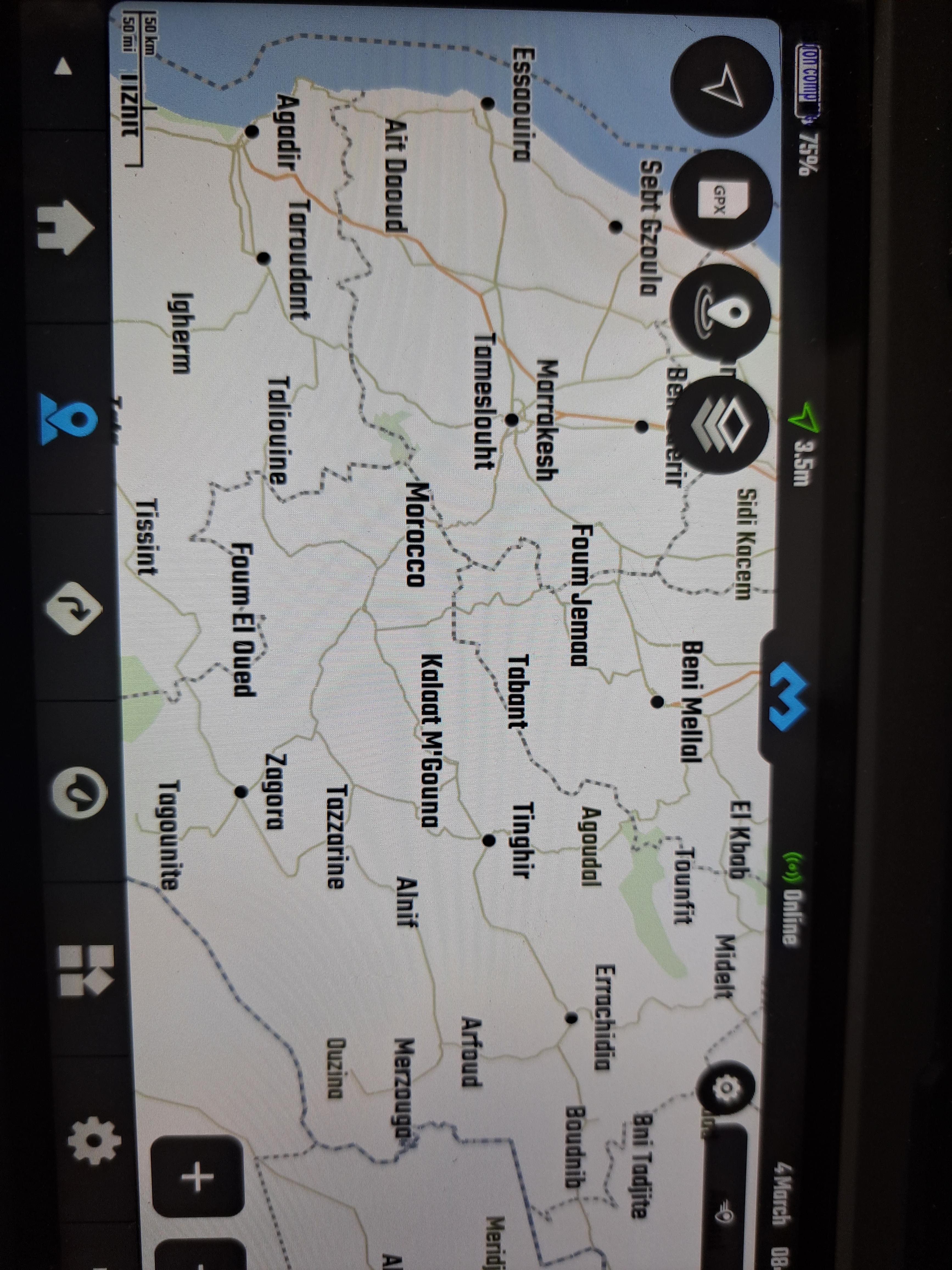
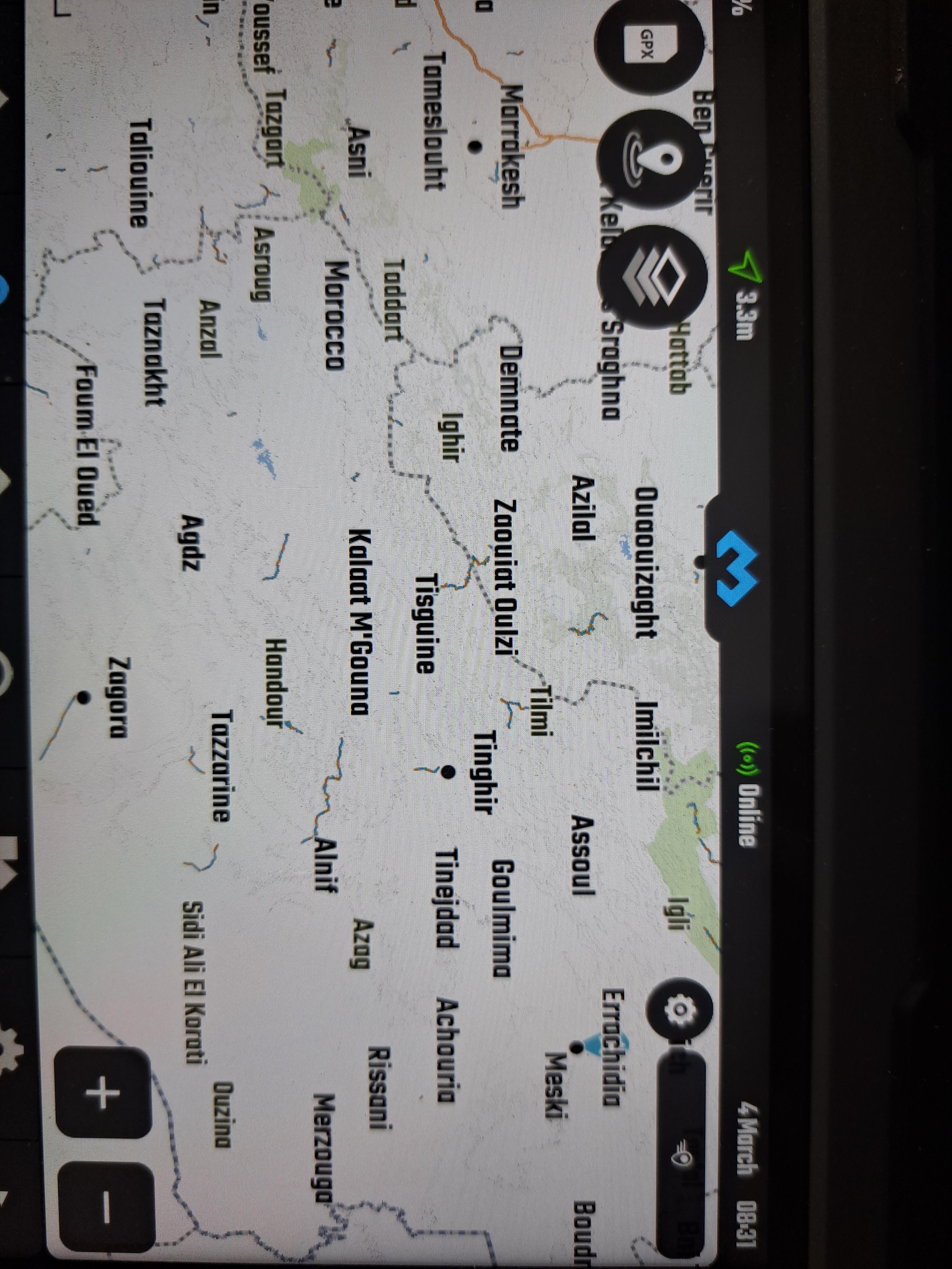
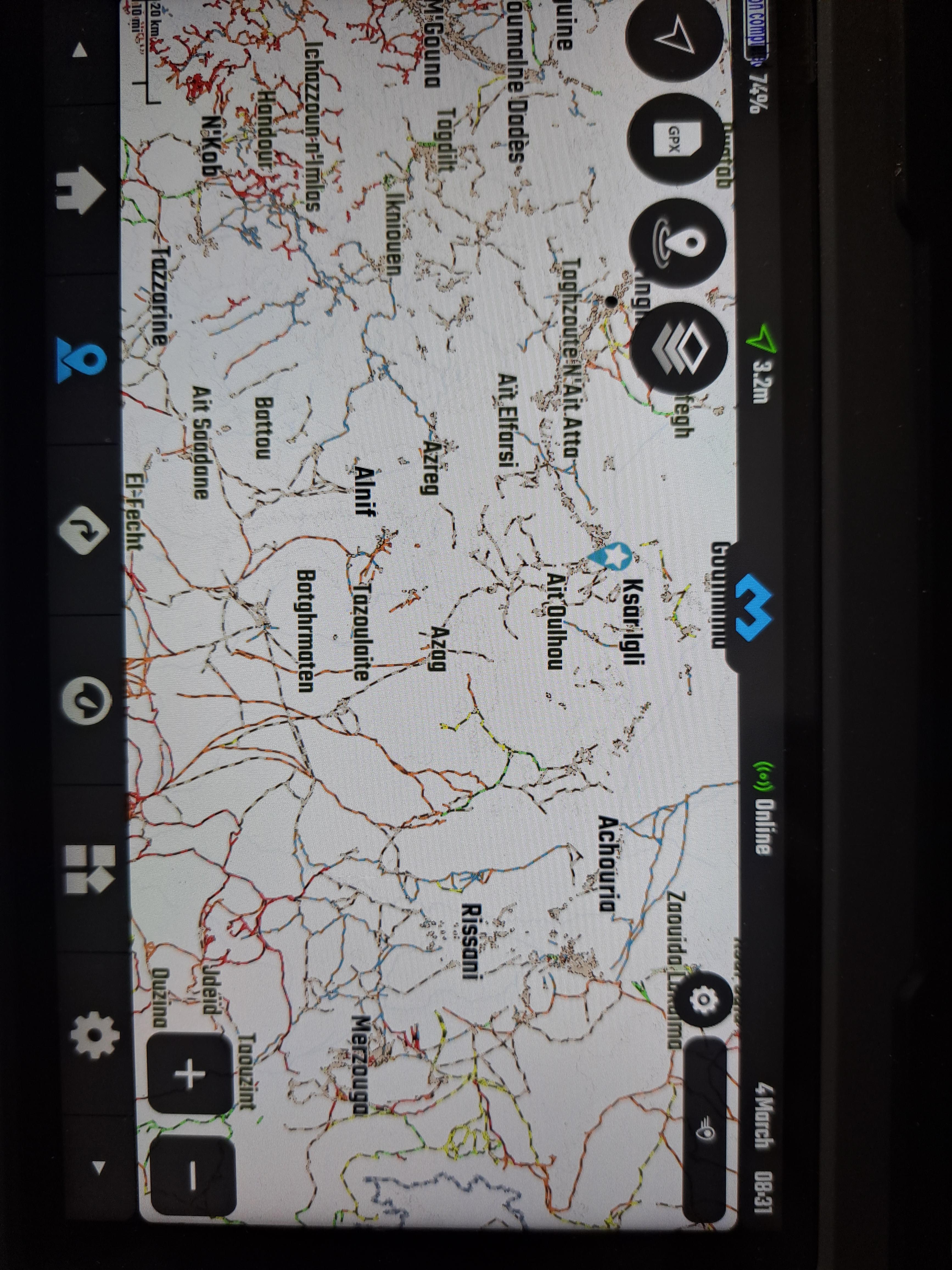
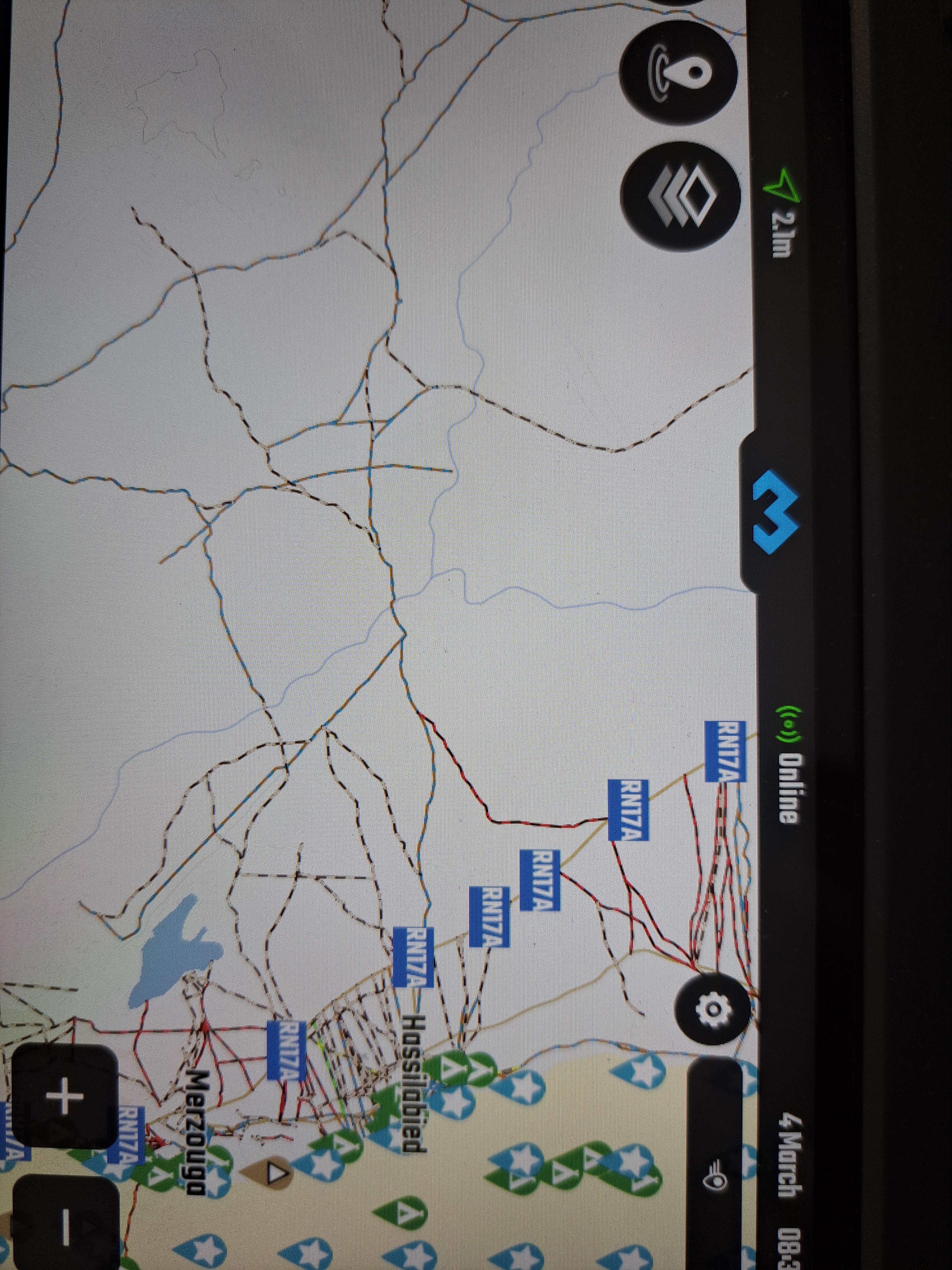
I have a little issue with maps, perhaps it is me, but I need your help.
When I open a map (eg Morocco), I can clearly see the main roads; if I zoom in a bit, they totally disappear, only many minor tracks are present, and it is impossible to use the map (IMO, this should not happen); if I zoom in much further, some provincial roads reappear (R and N roads), but by then we lost the complete picture and it is hardly usable. It is very confusing.
Is it just me? What am I doing wrong?
-
This reply was modified 1 year, 2 months ago by
 Bibo.
Bibo.
4 March 2023 at 1:23 pm #1349BiboParticipantI am on 2.95.
I have an issue with maps, probably it is me, but I need your help.
When I open a map, I see the major roads (for ex., Morocco); if I zoom in a bit, I loose all references to those roads and only very minor tracks are visible; only if I zoom in further (a lot), I start seeing the provincial roads again but it is impossible to make any planning. I am confused, is this normal?!
(I will try to attach some pics)
-
This reply was modified 1 year, 2 months ago by Bibo.
-
This reply was modified 1 year, 2 months ago by Bibo.
-
This reply was modified 1 year, 2 months ago by Bibo.
-
This reply was modified 1 year, 2 months ago by Bibo.
-
This reply was modified 8 months, 2 weeks ago by
 João Pereira.
21 February 2023 at 2:54 pm #1267BiboParticipant2.89 here on Carpe Iter Pad
Is it possible to load a GPX from an external source like GoogleDrive directly? Or does it always have to be downloaded separetly and then load it from internal drive?
18 February 2023 at 7:56 am #1254BiboParticipantUsing beta 2.84 for 1st time, as my primary interest is in Africa navigation, I noticed that many country maps are still missing. After an initial review: Senegal, Ghana, Togo, Benin, (maybe the last 3 are under West Africa), South Sudan, Sudan and surprisingly Egypt. Furthermore, after checking Morocco+Mauritania, I noticed that the town names are in Western name/Greek/Arabic, but prevalently Arabic. It is very confusing. There should be an option in Setting for choosing, e.g. “Western only”. I also tried to select Off Road Topo in Map Style, but nothing changes in the layout with or without Reset.
I am absolutely sure all maps are included but maybe some countries are bundled together, I will check and correct names. Choosing map language is already in the todo list, will try to fix that!
I managed to download beta 2.88 on the Carpe Iter.
For Morocco and Mauritania the names are still in Western name/Greek/Arabic. Did you change anything yet on that regard?
18 February 2023 at 7:37 am #1253BiboParticipantI still cannot change the avatar.
Is there a size limit on the file?
I tried to change JPG to JPEG to no avail.
I tried different sizes and formats.When I select a file, the file name always appears, but image never appears inside avatar window.
16 February 2023 at 6:49 pm #1224BiboParticipantJust signed up for the Beta and tried installing from a Carpe tablet. It says “Can’t Install DMD2. Try again and if it still doesn’t work see common ways to fix the problem”. I have plenty of storage space available, and am on my home wifi. Any ideas?
+1
I am having the same problem, but only the Carpe tablet. On my phone I can update to the latest betas.
14 February 2023 at 3:43 pm #1185BiboParticipantI checked a 2nd time: Senegal, Ghana, Togo and Benin are bundled together as West Africa, with all the countries in between. If Egypt and Sudan are bundled somewhere, I don’t know, but they should be on their own. The names are in Arabic in Morocco and Mauritania, but in West Africa and Mali they are correct. Does Off Road Topo view work for you?
Egypt and Sudan are both in Middle East, not sure that makes sense, maybe we should change it to MENA (Middle East and North Africa)? And yes Off-Road Topo is working for everyone… not sure why you are saying it is not working.
As far as I am concerned, they should be in Africa – period. Egypt, Sudan and South Sudan. Map wise, is UK part of Europe? Of course it is 😇
For OR Topo I just click on the new style and nothing changes in view even if I zoom. Just a guess, have you tried on the Morocco + Mauritania maps?
13 February 2023 at 10:07 pm #1183BiboParticipantUsing beta 2.84 for 1st time, as my primary interest is in Africa navigation, I noticed that many country maps are still missing. After an initial review: Senegal, Ghana, Togo, Benin, (maybe the last 3 are under West Africa), South Sudan, Sudan and surprisingly Egypt. Furthermore, after checking Morocco+Mauritania, I noticed that the town names are in Western name/Greek/Arabic, but prevalently Arabic. It is very confusing. There should be an option in Setting for choosing, e.g. “Western only”. I also tried to select Off Road Topo in Map Style, but nothing changes in the layout with or without Reset.
I am absolutely sure all maps are included but maybe some countries are bundled together, I will check and correct names. Choosing map language is already in the todo list, will try to fix that!
I checked a 2nd time: Senegal, Ghana, Togo and Benin are bundled together as West Africa, with all the countries in between. If Egypt and Sudan are bundled somewhere, I don’t know, but they should be on their own.
The names are in Arabic in Morocco and Mauritania, but in West Africa and Mali they are correct.
Does Off Road Topo view work for you?
-
This reply was modified 1 year, 2 months ago by
-
AuthorPosts